ߞߐߕߐ߮:Sikasso cercles.png
ߊ߬ ߢߍߦߋߟߌ ߢߊ߲ߞߊ߲: ߔߌߞߑߛߍߟ ߇߃߈ × ߅߉߉. ߢߊߓߐߟߌ ߟߎ߬ ߕߐ߬ߡߊ ߔߌߞߑߛߍߟ ߂߉߆ × ߂߄߀ | ߔߌߞߑߛߍߟ ߅߉߁ × ߄߈߀ | ߔߌߞߑߛߍߟ ߉߅߃ × ߇߇߄.
ߞߐߕߐ߮ ߓߊߛߎ߲ (߉߅߃ × ߇߇߄ ߖߌ߬ߦߊ߬ߘߊ߲ߕߊ߸ ߞߐߕߐ߮ ߢߊ߲ߞߊ߲: ߄߄ KB߸ MIME ߛߎ߮ߦߊ:image/png)
ߟߊߘߛߏߣߍ߲
| ߕߐ߯ߟߊߘߏ߲ |
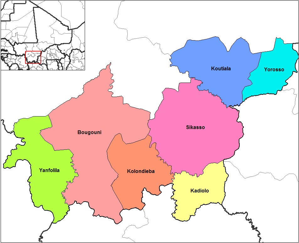
English: Map of the cercles of Sikasso region in Mali. Created using MapInfo Professional v8.5 and various mapping resources. |
| ߕߎ߬ߡߊ߬ߘߊ | |
| ߛߎ߲ | ߟߊ߫ ߓߊ߯ߙߊ ߟߋ߫ ߘߌ߫ |
| ߛߓߍߦߟߊ | Rarelibra |
| Other versions |
|

ߟߊ߬ߘߌ߬ߢߍ߬ߟߌ ߦߴߌ ߘߐ߫
| This work has been released into the public domain by its author, Rarelibra at ߊ߲߬ߜߑߟߋ߬ߞߊ߲ ߥߞߌߔߋߘߌߦߊ. This applies worldwide. In some countries this may not be legally possible; if so: Rarelibra grants anyone the right to use this work for any purpose, without any conditions, unless such conditions are required by law. |
Original upload log
The original description page was here. All following user names refer to en.wikipedia.
- 2006-09-18 15:32 Rarelibra 1056×816× (34502 bytes) Map of the cercles of Sikasso region in Mali. Created by ~~~~ for public domain use, using MapInfo Professional v8.5 and various mapping resources.
ߞߐߕߐ߮ ߟߊ߫ ߘߐ߬ߝߐ
ߕߎ߬ߡߊ߬ߘߊ/ߕߎ߬ߡߊ ߛߐ߲߬ߞߌ߲߬ ߓߊ߫߸ ߞߊ߬ ߕߎ߬ߡߊ߬ߘߊ ߞߐߕߐ߮ ߟߎ߬ ߦߋ߫.
| ߕߎ߬ߡߊ߬ߘߊ/ߕߎ߬ߡߊ߬ߟߊ߲ | ߞߝߊ߬ߟߋ߲ߛߋ߲ | ߛߎߡߊ߲ߘߐ | ߟߊ߬ߓߊ߰ߙߊ߬ߟߊ | ߞߊ߲߬ߝߐߟߌ | |
|---|---|---|---|---|---|
| ߞߍߛߊ߲ߞߏ | ߁߄:߃߅, ߁߆ ߞߏ߲ߞߏߘߌ߬ߓߌ ߂߀߁߂ | | ߉߅߃ × ߇߇߄ (߄߄ KB) | Adrian12 | Reduce |
| ߁߄:߂߀, ߁߀ ߘߓߊ߬ߓߌߟߊ ߂߀߁߀ |  | ߁,߀߅߆ × ߈߁߆ (߃߄ KB) | File Upload Bot (Magnus Manske) | {{BotMoveToCommons|en.wikipedia|year={{subst:CURRENTYEAR}}|month={{subst:CURRENTMONTHNAME}}|day={{subst:CURRENTDAY}}}} {{Information |Description={{en|Map of the cercles of Sikasso region in Mali. Created by Rarelibra 15:32, 18 Sep |
ߞߐߕߐ߮ ߟߊߓߊ߯ߙߊߟߌ
ߞߐߜߍ 1 ߟߎ߬ ߦߋ߫ ߞߐߕߐ߮ ߣߌ߲߬ ߠߊߓߊ߯ߙߊ߫ ߟߊ߫:
ߞߐߕߐ߮ ߟߊߓߊ߯ߙߊߟߌ߫ ߞߙߎߞߙߍ
ߥߞߌ߫ ߕߐ߭ ߢߌ߲߬ ߠߎ߬ ߦߋ߫ ߞߐߕߐ߮ ߣߌ߲߬ ߠߊߓߊ߯ߙߊ߫ ߟߊ߫:
- ߊ߬ ߟߊߓߊ߯ߙߊ߫ en.wikipedia.org ߘߐ߫
- ߊ߬ ߟߊߓߊ߯ߙߊ߫ es.wikipedia.org ߘߐ߫
- ߊ߬ ߟߊߓߊ߯ߙߊ߫ et.wikipedia.org ߘߐ߫
- ߊ߬ ߟߊߓߊ߯ߙߊ߫ fa.wikipedia.org ߘߐ߫
- ߊ߬ ߟߊߓߊ߯ߙߊ߫ fi.wikipedia.org ߘߐ߫
- ߊ߬ ߟߊߓߊ߯ߙߊ߫ frr.wikipedia.org ߘߐ߫
- ߊ߬ ߟߊߓߊ߯ߙߊ߫ fr.wikipedia.org ߘߐ߫
- ߊ߬ ߟߊߓߊ߯ߙߊ߫ hu.wikipedia.org ߘߐ߫
- ߊ߬ ߟߊߓߊ߯ߙߊ߫ it.wikipedia.org ߘߐ߫
- ߊ߬ ߟߊߓߊ߯ߙߊ߫ ja.wikipedia.org ߘߐ߫
- ߊ߬ ߟߊߓߊ߯ߙߊ߫ ka.wikipedia.org ߘߐ߫
- ߊ߬ ߟߊߓߊ߯ߙߊ߫ lt.wikipedia.org ߘߐ߫
- ߊ߬ ߟߊߓߊ߯ߙߊ߫ nds.wikipedia.org ߘߐ߫
- ߊ߬ ߟߊߓߊ߯ߙߊ߫ nl.wikipedia.org ߘߐ߫
- ߊ߬ ߟߊߓߊ߯ߙߊ߫ no.wikipedia.org ߘߐ߫
- ߊ߬ ߟߊߓߊ߯ߙߊ߫ pl.wikipedia.org ߘߐ߫
- ߊ߬ ߟߊߓߊ߯ߙߊ߫ ru.wikipedia.org ߘߐ߫
- ߊ߬ ߟߊߓߊ߯ߙߊ߫ si.wikipedia.org ߘߐ߫
- ߊ߬ ߟߊߓߊ߯ߙߊ߫ sw.wikipedia.org ߘߐ߫
- ߊ߬ ߟߊߓߊ߯ߙߊ߫ uk.wikipedia.org ߘߐ߫