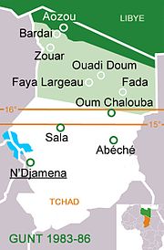
ߞߐߕߐ߮:Tschad GUNT.jpg

ߊ߬ ߢߍߦߋߟߌ ߢߊ߲ߞߊ߲: ߔߌߞߑߛߍߟ ߃߉߃ × ߅߉߉. ߢߊߓߐߟߌ ߟߎ߬ ߕߐ߬ߡߊ ߔߌߞߑߛߍߟ ߁߅߇ × ߂߄߀ | ߔߌߞߑߛߍߟ ߄߂߀ × ߆߄߀.
ߞߐߕߐ߮ ߓߊߛߎ߲ (߄߂߀ × ߆߄߀ ߖߌ߬ߦߊ߬ߘߊ߲ߕߊ߸ ߞߐߕߐ߮ ߢߊ߲ߞߊ߲: ߉߅ KB߸ MIME ߛߎ߮ߦߊ:image/jpeg)
ߞߐߕߐ߮ ߟߊ߫ ߘߐ߬ߝߐ
ߕߎ߬ߡߊ߬ߘߊ/ߕߎ߬ߡߊ ߛߐ߲߬ߞߌ߲߬ ߓߊ߫߸ ߞߊ߬ ߕߎ߬ߡߊ߬ߘߊ ߞߐߕߐ߮ ߟߎ߬ ߦߋ߫.
| ߕߎ߬ߡߊ߬ߘߊ/ߕߎ߬ߡߊ߬ߟߊ߲ | ߞߝߊ߬ߟߋ߲ߛߋ߲ | ߛߎߡߊ߲ߘߐ | ߟߊ߬ߓߊ߰ߙߊ߬ߟߊ | ߞߊ߲߬ߝߐߟߌ | |
|---|---|---|---|---|---|
| ߞߍߛߊ߲ߞߏ | ߁߉:߃߀, ߆ ߘߓߊ߬ߕߊ ߂߀߁߀ |  | ߄߂߀ × ߆߄߀ (߉߅ KB) | Roxanna | +Fada |
| ߂߂:߀߀, ߅ ߘߓߊ߬ߕߊ ߂߀߁߀ |  | ߄߂߀ × ߆߄߀ (߁߃߁ KB) | Roxanna | {{Information |Description={{en|1=GUNT-controlled area in Chad until 1986/87, "red line" on 15th and 16th latitude (1983 and 1984) and Libyan-occupied Aouzou-strip}} {{de|1=Von Oueddeis GUNT kontrollierte Gebiete im Tschad bis 1986/87, die von Frankreich |
ߞߐߕߐ߮ ߟߊߓߊ߯ߙߊߟߌ
ߞߐߜߍ 1 ߟߎ߬ ߦߋ߫ ߞߐߕߐ߮ ߣߌ߲߬ ߠߊߓߊ߯ߙߊ߫ ߟߊ߫:
ߞߐߕߐ߮ ߟߊߓߊ߯ߙߊߟߌ߫ ߞߙߎߞߙߍ
ߥߞߌ߫ ߕߐ߭ ߢߌ߲߬ ߠߎ߬ ߦߋ߫ ߞߐߕߐ߮ ߣߌ߲߬ ߠߊߓߊ߯ߙߊ߫ ߟߊ߫:
- ߊ߬ ߟߊߓߊ߯ߙߊ߫ als.wikipedia.org ߘߐ߫
- ߊ߬ ߟߊߓߊ߯ߙߊ߫ ar.wikipedia.org ߘߐ߫
- ߊ߬ ߟߊߓߊ߯ߙߊ߫ azb.wikipedia.org ߘߐ߫
- ߊ߬ ߟߊߓߊ߯ߙߊ߫ bg.wikipedia.org ߘߐ߫
- ߊ߬ ߟߊߓߊ߯ߙߊ߫ ca.wikipedia.org ߘߐ߫
- ߊ߬ ߟߊߓߊ߯ߙߊ߫ da.wikipedia.org ߘߐ߫
- ߊ߬ ߟߊߓߊ߯ߙߊ߫ de.wikipedia.org ߘߐ߫
- ߊ߬ ߟߊߓߊ߯ߙߊ߫ en.wikipedia.org ߘߐ߫
- ߊ߬ ߟߊߓߊ߯ߙߊ߫ es.wikipedia.org ߘߐ߫
- ߊ߬ ߟߊߓߊ߯ߙߊ߫ fr.wikipedia.org ߘߐ߫
- ߊ߬ ߟߊߓߊ߯ߙߊ߫ id.wikipedia.org ߘߐ߫
- ߊ߬ ߟߊߓߊ߯ߙߊ߫ it.wikipedia.org ߘߐ߫
- ߊ߬ ߟߊߓߊ߯ߙߊ߫ ja.wikipedia.org ߘߐ߫
- ߊ߬ ߟߊߓߊ߯ߙߊ߫ ka.wikipedia.org ߘߐ߫
- ߊ߬ ߟߊߓߊ߯ߙߊ߫ nl.wikipedia.org ߘߐ߫
- ߊ߬ ߟߊߓߊ߯ߙߊ߫ no.wikipedia.org ߘߐ߫
- ߊ߬ ߟߊߓߊ߯ߙߊ߫ pl.wikipedia.org ߘߐ߫
- ߊ߬ ߟߊߓߊ߯ߙߊ߫ pt.wikipedia.org ߘߐ߫
- ߊ߬ ߟߊߓߊ߯ߙߊ߫ ru.wikipedia.org ߘߐ߫
- ߊ߬ ߟߊߓߊ߯ߙߊ߫ uk.wikipedia.org ߘߐ߫
- ߊ߬ ߟߊߓߊ߯ߙߊ߫ www.wikidata.org ߘߐ߫


